Introduction
The integrated use of drone and laser scanning technology is transforming blast monitoring in industries like mining and construction, offering unprecedented levels of safety, accuracy, and efficiency. These technologies provide a comprehensive and detailed understanding of the entire blasting process, from initial site assessment to post-blast analysis, ultimately leading to optimized results and a safer working environment.
The role of drones: an eye in the sky
Drones, or unmanned aerial vehicles (UAVs), equipped with high-resolution cameras and other sensors, serve as a versatile platform for collecting critical data throughout the blasting lifecycle [1].
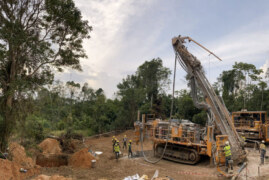
Before a blast, drones are instrumental in conducting detailed site surveys [2]. They can quickly and safely map large and often hazardous areas, providing engineers with precise topographical data [3]. This information is crucial for:
- Optimizing blast design: accurate 3D models generated from drone imagery allow for the precise placement of drill holes and the calculation of explosive quantities, ensuring the blast is effective and contained.
- Identifying potential hazards: drones can identify geological features, such as cracks or unstable ground, that could pose a risk during the blast [4].
- Establishing exclusion zones: by providing a comprehensive aerial view, drones help in clearly defining and monitoring the safe zones around the blast area [1].
During a blast, drones can be positioned at a safe distance to record the event from multiple angles. This footage is invaluable for:
- Verifying blast sequence and timing: the high-frame-rate video allows for a detailed analysis of the detonation sequence, ensuring all explosives fired as planned.
- Monitoring for flyrock and dust clouds: drones can track the trajectory of debris and the dispersion of dust, providing crucial data for safety and environmental compliance.
After the blast, drones are used to quickly assess the results, a process that was traditionally time-consuming and dangerous [2]. Their key post-blast functions include:
- Muckpile analysis: drones capture images that are used to create 3D models of the fragmented rock pile [1]. This data helps in calculating the volume of the blasted material and assessing its fragmentation, which is a key indicator of blast efficiency [2].
- Face profiling: they can survey the new rock face to ensure it is stable and conforms to the desired design.
- Inspecting for misfires: a drone’s aerial perspective allows for a rapid and safe inspection of the blast area for any unexploded charges.
The power of laser scanning (LiDAR): precision in three dimensions
Laser scanning, often referred to as LiDAR (Light Detection and Ranging), provides highly accurate 3D measurements of the blast site [5]. When mounted on drones or used as terrestrial scanners, LiDAR systems emit laser pulses and measure the reflected light to create a dense “point cloud” of data [6]. This point cloud is then used to generate incredibly detailed and precise 3D models.
The primary roles of laser scanning in blast monitoring include:
- Pre-blast face profiling and burden analysis: LiDAR scans create a precise digital twin of the rock face, allowing for accurate measurement of the “burden” – the distance from the drill hole to the free face. This is a critical parameter for a successful blast.
- Post-blast fragmentation analysis: by scanning the muckpile, LiDAR can provide detailed information on the size distribution of the fragmented rock. This data is essential for optimizing crusher performance and the overall efficiency of the mining or construction operation.
- Volume calculations: LiDAR provides highly accurate volumetric measurements of both the pre-blast rock mass and the post-blast muckpile, enabling precise reconciliation of material moved.
- Change detection: comparing pre- and post-blast LiDAR scans allows for a detailed analysis of how the rock mass has moved and fractured, providing valuable insights for future blast designs.
The synergy of drones and laser scanning
The combination of drone agility and the precision of laser scanning creates a powerful tool for blast monitoring. Drones can quickly deploy LiDAR sensors to otherwise inaccessible or dangerous areas, providing a comprehensive and accurate dataset in a fraction of the time it would take using traditional survey methods [7]. This integration leads to significant benefits, including:
- Enhanced safety: by removing the need for personnel to enter hazardous blast zones for surveying and inspection, the risk of accidents is dramatically reduced [8].
- Improved accuracy and efficiency: the high-resolution data collected by these technologies leads to more precise blast designs, better fragmentation, and optimized resource allocation [2].
- Cost savings: more efficient blasts mean less rework, reduced explosive usage, and lower operational costs [4].
- Comprehensive data for analysis: the wealth of data generated allows for continuous improvement of blasting practices and better-informed decision-making [8].
Conclusion
In short, application of drone and laser scanning technology is a significant advance in blast monitoring. By providing a safer, more accurate, and efficient technique for data acquisition and analysis, the two technologies are serving to be invaluable to the optimization of blasting operations and ensuring the safety of individuals in the mining and construction industries.
Reference
[1] N. B. Inc, “Drone Mining Inspection – Drone Mining & Services – Drones for Drilling & Blasting | Nelson Brothers Inc.” Accessed: Sept. 25, 2025. [Online]. Available: https://www.nelsonbrothers.com/services/drone-technology/
[2] “How Mining Drones Improve Safety & Efficiency for Mining Operations | SafeSight Exploration.” Accessed: Sept. 25, 2025. [Online]. Available: https://safesightxp.com/2021/11/15/drone-technology-for-the-mining-industry/
[3] “Benefits of Drone Technology in Blast Surveys | Agg-Net.” Accessed: Sept. 25, 2025. [Online]. Available: https://www.agg-net.com/resources/articles/drilling-blasting/benefits-of-drone-technology-in-blast-surveys
[4] GroundProbe, “An Innovative Approach to Blast Analytics,” GroundProbe. Accessed: Sept. 25, 2025. [Online]. Available: https://www.groundprobe.com/an-innovative-approach-to-blast-analytics/
[5] “A complete guide to drone surveys in 3D Laser Scanning.” Accessed: Sept. 25, 2025. [Online]. Available: https://redlaser.co.uk/drone-surveys-services/
[6] “Drones et LiDAR : Révolution dans l’arpentage,” YellowScan. Accessed: Sept. 25, 2025. [Online]. Available: https://www.yellowscan.com/knowledge/drones-for-surveying/
[7] admin, “What is Drone LiDAR Scanner? | Tips to Choose and Use it,” LiDAR Solutions Australia. Accessed: Sept. 25, 2025. [Online]. Available: https://www.lidarsolutions.com.au/blog/knowledge/all-you-need-know-about-drone-lidar-scanners/
[8] T. Bamford, F. Medinac, and K. Esmaeili, “Continuous Monitoring and Improvement of the Blasting Process in Open Pit Mines Using Unmanned Aerial Vehicle Techniques,” Remote Sensing, vol. 12, no. 17, p. 2801, Jan. 2020, doi: 10.3390/rs12172801.