Data lives where people shouldn’t
Underground mining has always demanded a difficult trade-off: the most critical data often lies in the dangerous places where people can not access safely. Stopes, ore passes, headings, and old workings hold essential information for production, reconciliation, and geotechnical confidence—yet accessing them safely has remained a persistent challenge.
For years, mining professionals have accepted delays, incomplete datasets, and exposure to risk as unavoidable realities of underground surveying. Today, that assumption is no longer valid. A new generation of Emesent’s fully autonomous mapping technology is transforming how underground voids are explored, mapped, and understood—without putting people in harm’s way.
The persistent challenge of underground mapping
Accurate stope geometry and volume measurements are fundamental to underground mining success. They directly influence:
- Design compliance and reconciliation
- Ore dilution assessment
- Blasting performance and recovery
- Ground stability and operational safety
Traditionally, Cavity Monitoring Systems (CMS) have been the standard tool for stope measurement. While widely used, they come with inherent limitations:
- Manual setup at the stope edge exposes personnel to falls, rock instability, and poor air quality
- Stationary scanning leads to shadowing and incomplete datasets
- Lengthy setup and processing times delay production decisions
Drone-based solutions have offered improvements, but many still depend on continuous communication links, waypoint planning, and pilot expertise. In narrow, complex, or communication-limited stopes, these systems often fall short.
Emesent has reached a major milestone in underground mapping with the release of Cortex™ 4.0 and Commander™ 2.1, delivering fully autonomous exploration and navigation in GPS-denied environments.

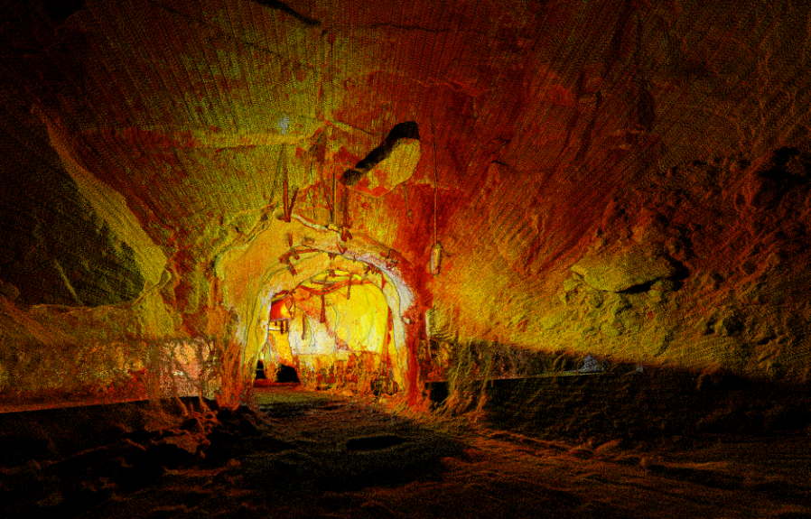
At the heart of this breakthrough is Hovermap, Emesent’s SLAM-based LiDAR scanning platform, already trusted by more than 200 hard-rock mines worldwide. What began as a solution for remote data capture in hazardous zones has evolved into a system capable of independent exploration, decision-making, and complete spatial mapping.
With Cortex 4.0, Hovermap no longer relies on predefined waypoints or constant operator input. Instead, it autonomously:
- Explores unknown voids
- Avoids obstacles in real time
- Filters dust and noise for clean data capture
- Operates reliably in darkness, wet conditions, and confined spaces
For underground surveyors, the impact is immediate and practical. This marks a fundamental shift from assisted flight to true autonomous surveying.
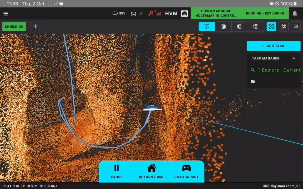
Using Commander, Emesent’s intuitive mission planning app, an operator simply defines a virtual bounding box around the target volume. From there, Hovermap takes over—autonomously exploring the stope, navigating voids as narrow as 2.4 meters, and capturing complete, high-resolution LiDAR data. There is:
- No need for line of sight
- No manual piloting
- No reliance on continuous communication links
Onboard processing delivers instant point clouds in the field, allowing surveyors to validate data quality immediately and move on—rather than waiting days for office-based reconciliation.
From box to scan, the entire workflow can be completed in minutes by a single operator with minimal training.
Safer people, better data, improved efficiency and faster decisions
The benefits of fully autonomous stope mapping extend far beyond convenience. By removing personnel from the stope edge, autonomous mapping significantly reduces exposure to geotechnical hazards, falls, and poor air quality—one of the most critical risk reductions in underground operations.
Mobile, autonomous scanning eliminates shadowing and captures complex geometries more completely than stationary CMS systems. This leads to:
- More reliable volume calculations
- Better dilution analysis
- Improved confidence in reconciliation results
Clients report up to 75% faster turnaround in stope reconciliation workflows. What once took days can now be achieved on site, enabling faster production decisions and reducing costly downtime.
Accurate, timely data is only valuable when it drives better outcomes. Fully autonomous mapping enables mining teams to:
- Verify design conformity with confidence
- Optimize blasting strategies using true void geometry
- Improve ore recovery and reduce dilution
- Strengthen geotechnical understanding and planning
By combining autonomy, reliability, and high-quality LiDAR data, Hovermap becomes more than a surveying tool, it becomes a decision-making enabler.
Technoligcal revolution
The evolution from manual CMS surveys to fully autonomous stope mapping represents more than a technological upgrade, it is a technological revolution. It signals a new standard for how underground mines manage risk, data, and productivity. Fully autonomous mapping is not the future of underground surveying. It is the new baseline.
If you want to know more about Emesent, visit: https://emesent.com/