Sign In


Forgot Password?

Don't have account, Sign Up Here

Forgot Password

Lost your password? Please enter your email address. You will receive a link and will create a new password via email.


Have an account? Sign In Now

Sorry, you do not have permission to Add a Post, You must login to Add a Post.


Forgot Password?

Need An Account, Sign Up Here

Sorry, you do not have permission to add Article.


Forgot Password?

Need An Account, Sign Up Here

Please briefly explain why you feel this Post should be reported.

Please briefly explain why you feel this Comment should be reported.

Please briefly explain why you feel this user should be reported.

Mining Doc Logo Mining Doc Logo Mining Doc Logo
Sign InSign Up

Mining Doc

Mining Doc Navigation

  • Home
    • About
    • Contact us
  • Mining articles
  • Online Courses
Search
Sign up

Mobile menu

Close
join for free
  • Home
  • Online courses
  • Case study
  • Mining Community
  • Solutions listing
    • Lase Solutions
    • O-PitBlast Solutions
    • Continuous Mining
    • Longwall mining
    • Geosight Scanners
    • LoopX AI
    • Terafil solutions
    • Blasting solutions
    • Geotechnical
    • Submersible Pumps
    • Mine rescue system
    • Ore sorting
    • Whittle Consulting Solutions
  • Add Blog
  • Feed
  • User Profile
  • Posts
    • New Posts
    • Trending Posts
    • Must read Posts
    • Hot Posts
  • Polls
  • Badges
  • Home
    • About
    • Contact us
  • Mining articles
  • Online Courses

Mining Doc Latest Posts

Mining Doc
  • 0
  • 0
Mining DocExplainer
Added: June 3, 20262026-06-03T05:50:23-04:00 2026-06-03T05:50:23-04:00In: Geology

How do you conduct a systematic structural geological mapping campaign to define fold and fault architecture in an underground mine?

  • 0
  • 0

A systematic structural geological mapping program is critical to determine the fold and fault structure of the mine. Such structural knowledge is necessary not only in determining the mineral resources but also in ensuring mine stability and safety (De Waele et al., 2018). The following is a proposed method of performing a thorough mapping program:

Direct face mapping and scanline surveys

The basis for any project is direct physical examination. The geologist makes detailed face mapping and scanline surveys in the exposed underground drifts. It is a very time-consuming process of detailed registration of strike and dip, spatial distribution of planar features, contacts of various lithologies, locations of fold hinges, and fault gouges. Recognition of the kinematic markers in these surveys will help trace successive deformational events and define the genetic linkages between structures and ore minerals (De Waele et al., 2018).

Multi-hole borehole imaging interpretation

Since physical access is limited to tunnels that have been excavated, structural data has to be interpreted through the process of diamond drilling exploration. Optical borehole televiewer (OTV) high-resolution imaging is utilized in the interpretation of defect spacings, natural fractures, and fractured zones within the rock body. Comparison of data obtained from deviated and vertical holes will enable geologists to create a quick 3D structural model that precisely identifies structural arrangements like fold plunges and fault dips (Dashti et al., 2019).

Incorporating 3D seismic and geophysical data

In order to define the structure of the rock mass especially between seams and interburdens, the high resolution 3D seismic survey is extremely important. Instead of focusing only on amplitude data, the geologists use structural attributes such as the instantaneous phase and frequency attributes. Structural attributes focus largely on event continuity. This enables the identification of angularities, discontinuities and fault pinches, which physical mapping cannot achieve (Paridon & Brandimarte, 2012).

Monitoring spatial changes in real time

Due to the dynamic changes occurring in the architecture of a mine due to its development process, monitoring is done in real time and is considered the last phase. Today’s mining uses the concept of geographic mapping in form of ultra sonic spherical array models to monitor the dynamic changes that occur as a result of mining (Zheng et al., 2013).

Through the integration of observations, well images, and attributes in the seismic wave, it is possible to define the underground architecture and maximize safety and mining efficiency.

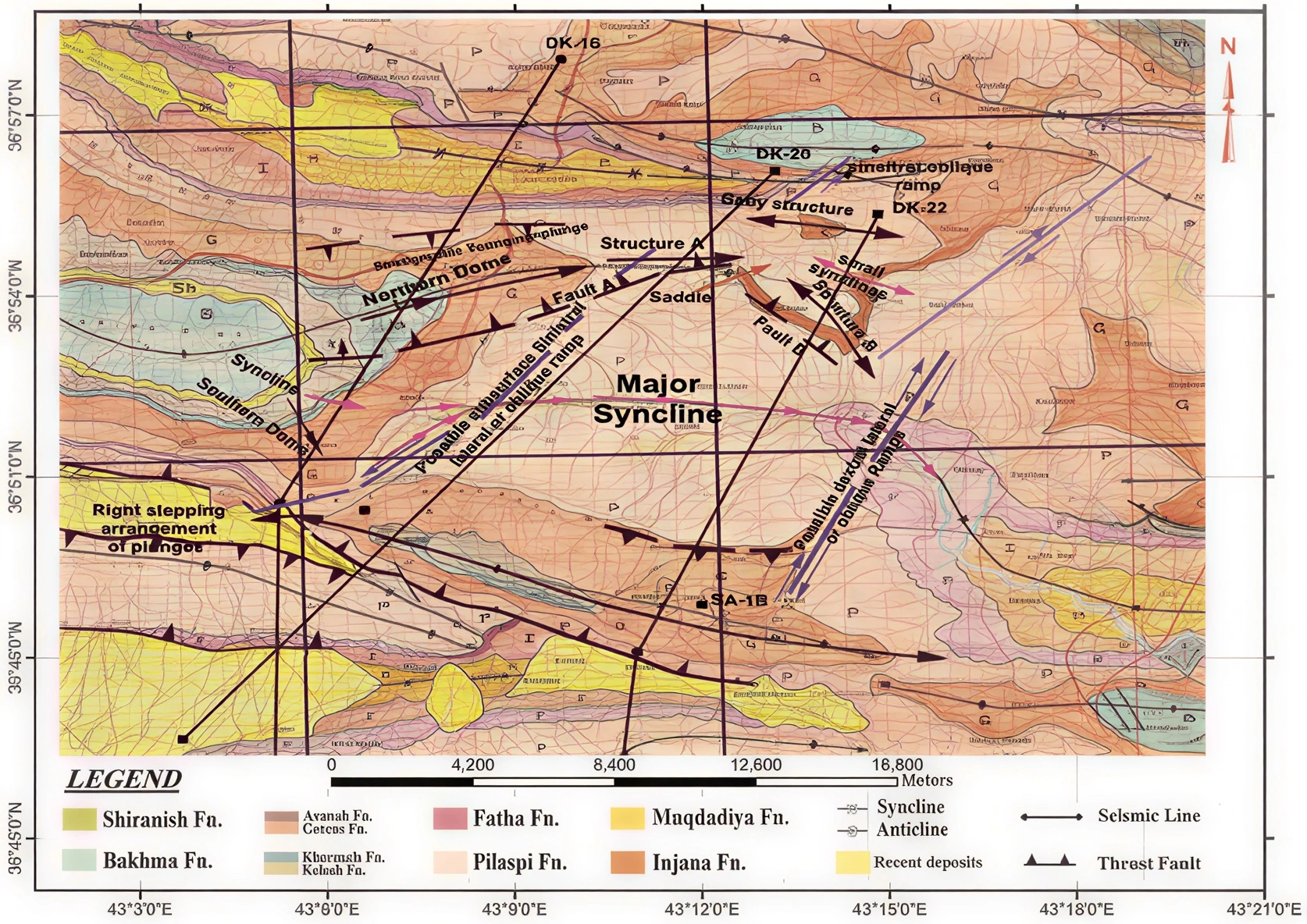
Image source: A structure geological map of the study area compiled from the field data, interpreted seismic sections (Sissakian, 1994)
References

Dashti, R., Birt, B., & Jangani, M. (2019). Quick structural modelling using multi-hole borehole image analysis; a critical input in mine planning. ASEG Extended Abstracts, 2019(1), 1–3. https://doi.org/10.1080/22020586.2019.12073016

De Waele, B., Lacorde, M., Cunningham, M., & Jupp, B. (2018). Understanding geology and structure: An essential part of mineral resource estimation. ASEG Extended Abstracts, 2018(1), 1–8. https://doi.org/10.1071/aseg2018abm2_2f

Paridon, H. v., & Brandimarte, F. (2012). Interburden mapping using 3D seismic attributes at an underground coal mine, Bowen Basin, Queensland. ASEG Extended Abstracts, 2012(1), 1–4. https://doi.org/10.1071/aseg2012ab416

Zheng, W., Li, Y., Lu, Q., & Lu, P. (2013). Geographic mapping model for underground structural deformation monitoring. Geomatics, Natural Hazards and Risk, 5(4), 353–372. https://doi.org/10.1080/19475705.2013.812994

How do you conduct a systematic structural geological mapping campaign to define fold and fault architecture in an underground mine?
0
  • 0 0 Comments
  • 18 Views
  • 18 Reactions
  • 0 Followers
  • 0
    • Report
  • Share
    Share
    • Share on Facebook
    • Share on Twitter
    • Share on LinkedIn
    • Share on WhatsApp

Related Posts

  • What are the key indicators used to differentiate between hypogene and supergene mineralisation in a porphyry copper system?
  • What is QA/QC in the context of mineral exploration and why is it critical to resource estimation?
  • What are the key indicators of a potentially economic skarn deposit during early-stage exploration?

You must login to add an Comment.


Forgot Password?

Need An Account, Sign Up Here
aalanaalan

Sidebar

  • Recent
  • Operational and Technical Parameters for Deploying a Crusher Plant in Saudi Arabia
    • On: June 3, 2026

    Operational and Technical Parameters for Deploying a Crusher Plant in ...

  • Durability and Design Requirements for Ready Mix Batching Plant from Mining Industry Use
    • On: June 2, 2026

    Durability and Design Requirements for Ready Mix Batching Plant from ...

  • The Key Role of Multi-Stage Screening in Crushing Plants
    • On: June 2, 2026

    The Key Role of Multi-Stage Screening in Crushing Plants

    • On: May 30, 2026

    Asphalt Drum Mix Plant for Sale Must Prove Slag Compatibility ...

  • How to Design a Granite Crusher Plant for Maximum Mining Output
    • On: May 30, 2026

    How to Design a Granite Crusher Plant for Maximum Mining ...

  • Rio Tinto commissions $1.5 billion low-carbon smelter expansion in Quebec
    • On: May 30, 2026

    Rio Tinto commissions $1.5 billion low-carbon smelter expansion in Quebec

  • Can Traditional Mining Survive Without Smart Digital Transformation?
    • On: May 26, 2026

    Can Traditional Mining Survive Without Smart Digital Transformation?

Go to Home page to view more

Top Members

Olena Skyba

Olena Skyba

  • 150 Posts
  • 2 Comments
Pundit
Marcial

Marcial

  • 91 Posts
  • 0 Comments
Enlightened
Jean Marais (Sanodea Group)

Jean Marais (Sanodea Group)

  • 25 Posts
  • 0 Comments
Beginner
Trending on Mining Doc

Trending Communities

Fixed Plant General Information Geology Mining Case Studies Mining Doc Documentary Mining Engineering Mining Events Mining Finance and Economy Mining Human Resources Mining Industry Research Mining Operations Mining Software Solutions Mining Sustainability Mining Technology Solutions Mobile Plant Equipment

Explore

  • Home
  • Online courses
  • Case study
  • Mining Community
  • Solutions listing
    • Lase Solutions
    • O-PitBlast Solutions
    • Continuous Mining
    • Longwall mining
    • Geosight Scanners
    • LoopX AI
    • Terafil solutions
    • Blasting solutions
    • Geotechnical
    • Submersible Pumps
    • Mine rescue system
    • Ore sorting
    • Whittle Consulting Solutions
  • Add Blog
  • Feed
  • User Profile
  • Posts
    • New Posts
    • Trending Posts
    • Must read Posts
    • Hot Posts
  • Polls
  • Badges

Footer

Mining Doc

Join our community and connect with other people in the Mining industry for knowledge sharing.

Legal Stuff

  • Privacy Policy
  • Terms of Service

Help

  • Support
  • FAQs
  • How to add new content and how to promote a content
  • Compliance and guidelines
  • Subscribe to Mining Doc

Follow

© 2026 Mining Doc. All Rights Reserved