Sign In


Forgot Password?

Don't have account, Sign Up Here

Forgot Password

Lost your password? Please enter your email address. You will receive a link and will create a new password via email.


Have an account? Sign In Now

Sorry, you do not have permission to Add a Post, You must login to Add a Post.


Forgot Password?

Need An Account, Sign Up Here

Sorry, you do not have permission to add Article.


Forgot Password?

Need An Account, Sign Up Here

Please briefly explain why you feel this Post should be reported.

Please briefly explain why you feel this Comment should be reported.

Please briefly explain why you feel this user should be reported.

Mining Doc Logo Mining Doc Logo Mining Doc Logo
Sign InSign Up

Mining Doc

Mining Doc Navigation

  • Home
    • About
    • Contact us
  • Mining articles
  • Online Courses
Search
Sign up

Mobile menu

Close
join for free
  • Home
  • Online courses
  • Case study
  • Mining Community
  • Solutions listing
    • Lase Solutions
    • O-PitBlast Solutions
    • Continuous Mining
    • Longwall mining
    • Geosight Scanners
    • LoopX AI
    • Terafil solutions
    • Blasting solutions
    • Geotechnical
    • Submersible Pumps
    • Mine rescue system
    • Ore sorting
    • Whittle Consulting Solutions
  • Add Blog
  • Feed
  • User Profile
  • Posts
    • New Posts
    • Trending Posts
    • Must read Posts
    • Hot Posts
  • Polls
  • Badges
  • Home
    • About
    • Contact us
  • Mining articles
  • Online Courses

Mining Doc Latest Posts

Mining Doc
  • 0
  • 0
Mining DocExplainer
Added: October 20, 20262026-10-20T06:13:51-04:00 2026-10-20T06:13:51-04:00In: Geology

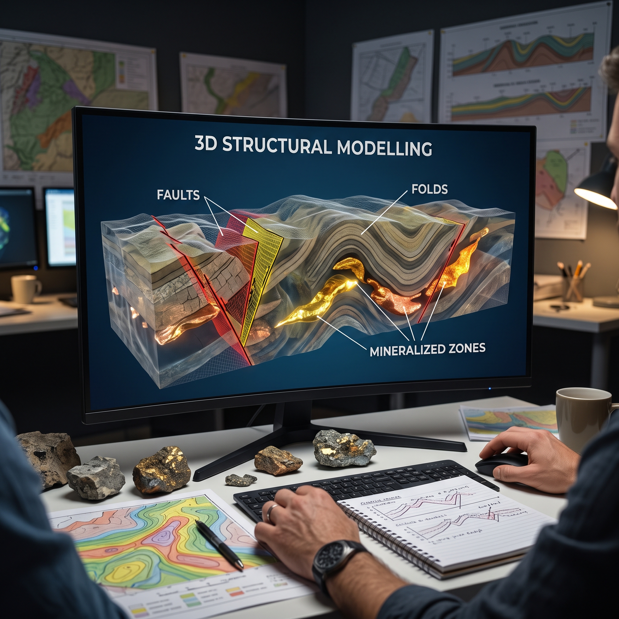
How does 3D structural modelling help identify faults, folds, and mineralized zones?

  • 0
  • 0

Traditional two-dimensional geological maps and cross-sections struggle to portray complex, polyphase subsurface architectures accurately. Implicit three-dimensional structural modelling addresses this limitation by unifying drill hole logs, surface outcrop mapping, mine level maps, and airborne geophysics into interactive digital volumes. Advanced interpolation algorithms transform discrete spatial observations into continuous structural surfaces and orebody models. This methodology allows geologists to reconstruct fault networks, unravel polyphase folding, and predict deep mineralised zones. Ultimately, digital workflow integration reduces exploration risk, resolves structural ambiguity, and improves target generation across complex tectonic terranes.

Fault systems govern fluid pathways and structural offsets within mineralised terranes. Modern 3D structural modelling integrates airborne aeromagnetic lineaments with drill core marker horizons to establish regional fault networks and imbricate fault duplexes. Advanced kinematic frameworks restore data points to pre-fault positions prior to surface interpolation, preserving displacement directions and overall geometric volume across faulted domains. Unlike conventional step functions that distort scalar fields and artificially shrink volume, kinematic restoration accommodates varying intersection angles between faults and folded host rocks. Furthermore, mapping these displacement vectors clarifies how fault conduits guide hydrothermal fluid flow and post-depositional shear movements throughout geological history.

Polyphase deformation severely complicates stratigraphic correlations and orebody morphology in complex terranes. Mathematical interpolation of bedding foliations, fold axes, and stretching lineations generates three-dimensional structural form-lines that portray complex fold networks. These models illuminate superimposed deformation events, such as asymmetric S-folds refolding earlier Z-folds, drag folds, and doubly plunging synforms. Structural analysis demonstrates how intense deformation creates thickened fold hinges that serve as key structural traps for high-grade ore. In addition, extensional shearing during progressive deformation stretches mineralised horizons into oblate or prolate megaboudins aligned with regional stretching lineations.

Three-dimensional implicit interpolation translates multi-element geochemical assays, lithological core logs, and historic mine plans into continuous solid ore bodies. Spatial interpolation techniques, including Radial Basis Functions, generate ore grade distributions constrained by lithological contacts and expert geological knowledge. High-resolution models highlight mineralisation enriched along granite contact zones, skarn interfaces, and altered fault feeders. The establishment of structural continuity enables the identification of unmined ore extensions and repeated stratigraphic horizons at depth. Consequently, exploration teams can delineate high-priority drilling targets in unexplored sectors far below legacy mining levels.

Three-dimensional structural modelling fundamentally advances subsurface interpretation by converting complex geological observations into explicit spatial frameworks. Geologists accurately resolve fault kinematics, unravel refolded structures, and trace ore grade distributions deep underground. The synthesis of geological constraints with mathematical interpolation reduces structural ambiguity in data-limited environments. As mineral exploration shifts toward deeper hidden deposits, 3D modelling serves as an indispensable tool for unearthing concealed mineral systems and optimizing drill targeting. This technology provides a scalable foundation for modern mineral resource assessment.
How does 3D structural modelling help identify faults, folds, and mineralized zones?
0
  • 0 0 Comments
  • 21 Views
  • 21 Reactions
  • 0 Followers
  • 0
    • Report
  • Share
    Share
    • Share on Facebook
    • Share on Twitter
    • Share on LinkedIn
    • Share on WhatsApp

Related Posts

  • How can 3D alteration modelling help identify potential mineralization targets during exploration?
  • How does 3D modelling of geological contacts reduce ore dilution and mining losses?
  • How does 3D geological modelling improve orebody delineation and mineral resource estimation?

You must login to add an Comment.


Forgot Password?

Need An Account, Sign Up Here
aalanaalanaalan

Sidebar

Sponsored Ads

aalan

Sponsored Ads

aalan

Sponsored Ads

aalan
Go to Home page to view more

Top Members

Olena Skyba

Olena Skyba

  • 150 Posts
  • 2 Comments
Pundit
Marcial

Marcial

  • 91 Posts
  • 0 Comments
Enlightened
Jean Marais (Sanodea Group)

Jean Marais (Sanodea Group)

  • 26 Posts
  • 0 Comments
Beginner
Trending on Mining Doc

Trending Communities

Fixed Plant General Information Geology Mining Case Studies Mining Doc Documentary Mining Engineering Mining Events Mining Finance and Economy Mining Human Resources Mining Industry Research Mining Operations Mining Software Solutions Mining Sustainability Mining Technology Solutions Mobile Plant Equipment

Explore

  • Home
  • Online courses
  • Case study
  • Mining Community
  • Solutions listing
    • Lase Solutions
    • O-PitBlast Solutions
    • Continuous Mining
    • Longwall mining
    • Geosight Scanners
    • LoopX AI
    • Terafil solutions
    • Blasting solutions
    • Geotechnical
    • Submersible Pumps
    • Mine rescue system
    • Ore sorting
    • Whittle Consulting Solutions
  • Add Blog
  • Feed
  • User Profile
  • Posts
    • New Posts
    • Trending Posts
    • Must read Posts
    • Hot Posts
  • Polls
  • Badges

Footer

Mining Doc

Join our community and connect with other people in the Mining industry for knowledge sharing.

Legal Stuff

  • Privacy Policy
  • Terms of Service

Help

  • Support
  • FAQs
  • How to add new content and how to promote a content
  • Compliance and guidelines
  • Subscribe to Mining Doc

Follow

© 2026 Mining Doc. All Rights Reserved