Sign In


Forgot Password?

Don't have account, Sign Up Here

Forgot Password

Lost your password? Please enter your email address. You will receive a link and will create a new password via email.


Have an account? Sign In Now

Sorry, you do not have permission to Add a Post, You must login to Add a Post.


Forgot Password?

Need An Account, Sign Up Here

Sorry, you do not have permission to add Article.


Forgot Password?

Need An Account, Sign Up Here

Please briefly explain why you feel this Post should be reported.

Please briefly explain why you feel this Comment should be reported.

Please briefly explain why you feel this user should be reported.

Mining Doc Logo Mining Doc Logo Mining Doc Logo
Sign InSign Up

Mining Doc

Mining Doc Navigation

  • Home
    • About
    • Contact us
  • Mining articles
  • Online Courses
Search
Sign up

Mobile menu

Close
join for free
  • Home
  • Online courses
  • Case study
  • Mining Community
  • Solutions listing
    • Lase Solutions
    • O-PitBlast Solutions
    • Continuous Mining
    • Longwall mining
    • Geosight Scanners
    • LoopX AI
    • Terafil solutions
    • Blasting solutions
    • Geotechnical
    • Submersible Pumps
    • Mine rescue system
    • Ore sorting
    • Whittle Consulting Solutions
  • Add Blog
  • Feed
  • User Profile
  • Posts
    • New Posts
    • Trending Posts
    • Must read Posts
    • Hot Posts
  • Polls
  • Badges
  • Home
    • About
    • Contact us
  • Mining articles
  • Online Courses

Mining Doc Latest Posts

Mining Doc
  • 0
  • 0
Mining DocBeginner
Added: July 2, 20262026-07-02T07:58:53-04:00 2026-07-02T07:58:53-04:00In: Mining Industry Research

How are remote sensing technologies (hyperspectral imaging, drone-mounted geophysics) changing the efficiency of early-stage mineral exploration?

  • 0
  • 0

Remote sensing techniques have revolutionized the way mining companies undertake early-stage mineral exploration. Remote sensing refers to the acquisition of information regarding the Earth’s surface through indirect contactless means. The two innovative remote sensing technologies that make a difference are Hyperspectral Imaging (HSI) and drones with geophysics technology.

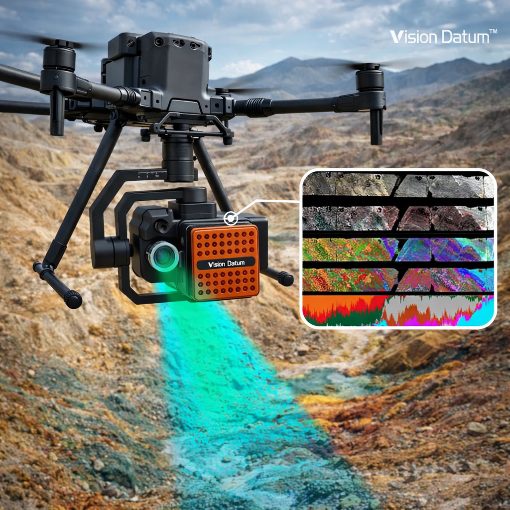
HSI uses electromagnetic radiations captured from hundreds of very narrow wavelengths per pixel to precisely detect material by making use of their spectral signature (Koerting et al., 2024). Drone geophysics entails installation of geophysical sensors on Uncrewed Aerial Systems (UASs) to detect geological formations underground (Heincke et al., 2019).

Traditionally, ground surveys were conducted using expensive and labor-intensive ground surveys or poor resolution satellite images. Early stage mineral exploration faced challenges in terms of inaccessibility. Fortunately, the development of high-resolution remote sensing has solved these issues. Modern-day drones allow flights of a low altitude which is a compromise between satellite coverage and ground sampling.

HSI technology has turned out to be extremely useful in discerning complicated mineral compositions. As geological formations have particular absorption characteristics in the visible to shortwave infrared range, HSI can quickly map differences in composition among exposed rocks (Kirsch et al., 2018). This way, geologists can locate mineralization zones without digging into the ground, thus speeding up the process of the discovery stage.

Simultaneously, geophysics from the drones becomes an essential source of underground data. Although HSI helps to identify chemical composition of rocks on the surface, drone-mounted magnetometers can find magnetic anomalies and geological formations (Heincke et al., 2019). The combination of magnetic and hyperspectral data collection from drone teams gives a multidimensional picture of the object of exploration.

The incorporation of these technologies makes it possible to increase efficiency, improve safety, and develop optimal sampling approaches. By creating geometrically correct digital representations of outcrops, it becomes possible for explorers to perform the analysis of lithologies without the need to visit the field (Kirsch et al., 2018).

To conclude, the combination of hyperspectral imaging and geophysical methods implemented via drones has revolutionized the process of mineral exploration. The technologies provide high-resolution geological information that directly decreases exploration risks.

References

Heincke, B., Jackisch, R., Saartenoja, A., Salmirinne, H., Rapp, S., Zimmermann, R., … & Middleton, M. (2019). Developing multi-sensor drones for geological mapping and mineral exploration: setup and first results from the MULSEDRO project. Geological Survey of Denmark and Greenland Bulletin, 43. https://doi.org/10.34194/geusb-201943-03-02

Kirsch, M., Lorenz, S., Zimmermann, R., Tusa, L., Möckel, R., Hödl, P., … & Gloaguen, R. (2018). Integration of Terrestrial and Drone-Borne Hyperspectral and Photogrammetric Sensing Methods for Exploration Mapping and Mining Monitoring. Remote Sensing, 10(9), 1366. https://doi.org/10.3390/rs10091366

Koerting, F., Asadzadeh, S., Hildebrand, J. C., Savinova, E., Kouzeli, E., Nikolakopoulos, K., … & Micklethwaite, S. (2024). VNIR-SWIR Imaging Spectroscopy for Mining: Insights for Hyperspectral Drone Applications. Mining, 4(4), 1013-1057. https://doi.org/10.3390/mining4040057

Image rights: Vision Datum (https://shop.visiondatum.com/blogs/blog/how-drone-based-hyperspectral-cameras-are-transforming-geological-mineral-exploration?srsltid=AfmBOorerS1TCct6bMRGp4snuYlJrTRTehwmbmjjVVH5oQZYUubOfHl1)
How are remote sensing technologies (hyperspectral imaging, drone-mounted geophysics) changing the efficiency of early-stage mineral exploration?
0
  • 0 0 Comments
  • 26 Views
  • 26 Reactions
  • 0 Followers
  • 0
    • Report
  • Share
    Share
    • Share on Facebook
    • Share on Twitter
    • Share on LinkedIn
    • Share on WhatsApp

Related Posts

  • What progress has been made in the development of coarse particle flotation technology, and how does it affect grinding circuit ...
  • What is the current state of battery-electric vehicle (BEV) technology for underground hard rock mining, and what are the barriers ...
  • What does the research say about the effectiveness of autonomous haulage systems (AHS) on mine productivity and safety?

You must login to add an Comment.


Forgot Password?

Need An Account, Sign Up Here
aalanaalan

Sidebar

  • Recent
  • Ready Mix Plants for Sale Used in Mining Camps and Industrial Plant Construction
    • On: July 1, 2026

    Ready Mix Plants for Sale Used in Mining Camps and ...

  • How Dual Power Track Crushers Reduce Fuel Costs in Heavy Duty Crushing Operations
    • On: July 1, 2026

    How Dual Power Track Crushers Reduce Fuel Costs in Heavy ...

  • Beyond ERP: Why Intelligent Finance Automation Is Reshaping Modern Mining
    • On: July 1, 2026

    Beyond ERP: Why Intelligent Finance Automation Is Reshaping Modern Mining

  • Finite Element Stress Analysis and Dynamic Load Dampening in Mining Logistics Infrastructure
    • On: July 1, 2026

    Finite Element Stress Analysis and Dynamic Load Dampening in Mining ...

  • Ore Crusher for Sale: Why Mobile Crushing Plants Are Gaining Popularity in Mining
    • On: July 1, 2026

    Ore Crusher for Sale: Why Mobile Crushing Plants Are Gaining ...

  • Gold on track for fourth weekly loss on hawkish Fed bets
    • On: June 26, 2026

    Gold on track for fourth weekly loss on hawkish Fed ...

  • Zimbabwe exploring minerals-backed deals with China to fund infrastructure
    • On: June 26, 2026

    Zimbabwe exploring minerals-backed deals with China to fund infrastructure

Go to Home page to view more

Top Members

Olena Skyba

Olena Skyba

  • 150 Posts
  • 2 Comments
Pundit
Marcial

Marcial

  • 91 Posts
  • 0 Comments
Enlightened
Jean Marais (Sanodea Group)

Jean Marais (Sanodea Group)

  • 25 Posts
  • 0 Comments
Beginner
Trending on Mining Doc

Trending Communities

Fixed Plant General Information Geology Mining Case Studies Mining Doc Documentary Mining Engineering Mining Events Mining Finance and Economy Mining Human Resources Mining Industry Research Mining Operations Mining Software Solutions Mining Sustainability Mining Technology Solutions Mobile Plant Equipment

Explore

  • Home
  • Online courses
  • Case study
  • Mining Community
  • Solutions listing
    • Lase Solutions
    • O-PitBlast Solutions
    • Continuous Mining
    • Longwall mining
    • Geosight Scanners
    • LoopX AI
    • Terafil solutions
    • Blasting solutions
    • Geotechnical
    • Submersible Pumps
    • Mine rescue system
    • Ore sorting
    • Whittle Consulting Solutions
  • Add Blog
  • Feed
  • User Profile
  • Posts
    • New Posts
    • Trending Posts
    • Must read Posts
    • Hot Posts
  • Polls
  • Badges

Footer

Mining Doc

Join our community and connect with other people in the Mining industry for knowledge sharing.

Legal Stuff

  • Privacy Policy
  • Terms of Service

Help

  • Support
  • FAQs
  • How to add new content and how to promote a content
  • Compliance and guidelines
  • Subscribe to Mining Doc

Follow

© 2026 Mining Doc. All Rights Reserved