Sign In


Forgot Password?

Don't have account, Sign Up Here

Forgot Password

Lost your password? Please enter your email address. You will receive a link and will create a new password via email.


Have an account? Sign In Now

Sorry, you do not have permission to Add a Post, You must login to Add a Post.


Forgot Password?

Need An Account, Sign Up Here

Sorry, you do not have permission to add Article.


Forgot Password?

Need An Account, Sign Up Here

Please briefly explain why you feel this Post should be reported.

Please briefly explain why you feel this Comment should be reported.

Please briefly explain why you feel this user should be reported.

Mining Doc Logo Mining Doc Logo Mining Doc Logo
Sign InSign Up

Mining Doc

Mining Doc Navigation

  • Home
    • About
    • Contact us
  • Mining articles
  • Online Courses
Search
Sign up

Mobile menu

Close
join for free
  • Home
  • Online courses
  • Case study
  • Mining Community
  • Solutions listing
    • Lase Solutions
    • O-PitBlast Solutions
    • Continuous Mining
    • Longwall mining
    • Geosight Scanners
    • LoopX AI
    • Terafil solutions
    • Blasting solutions
    • Geotechnical
    • Submersible Pumps
    • Mine rescue system
    • Ore sorting
    • Whittle Consulting Solutions
  • Add Blog
  • Feed
  • User Profile
  • Posts
    • New Posts
    • Trending Posts
    • Must read Posts
    • Hot Posts
  • Polls
  • Badges
  • Home
    • About
    • Contact us
  • Mining articles
  • Online Courses

Mining Doc Latest Posts

Mining Doc
  • -1
  • -1
Mining DocEnlightened
Added: May 19, 20262026-05-19T06:31:07-04:00 2026-05-19T06:31:07-04:00In: General Information

How is a 3D geological model built and what software tools are commonly used in the industry?

  • -1
  • -1

The creation of a 3D geological model entails creation of geological model based on a combination of data sets, including surface geology, boreholes, geophysics, and terrain information. The process is iterative as geologists interpret various geologic concepts through hypotheses testing until they come up with a subsurface model where boundaries and volumes fit perfectly.

In the first place, the geologists compile and clean all the available data. Geological maps, borehole information, cross section, terrain models, aeromagnetic, gravimetric, and seismic data are typical sources of data used in this case while other sources could be geochemical and geochronology. The reason why several data sets are employed in model creation is to improve chances of getting a true subsurface depiction.

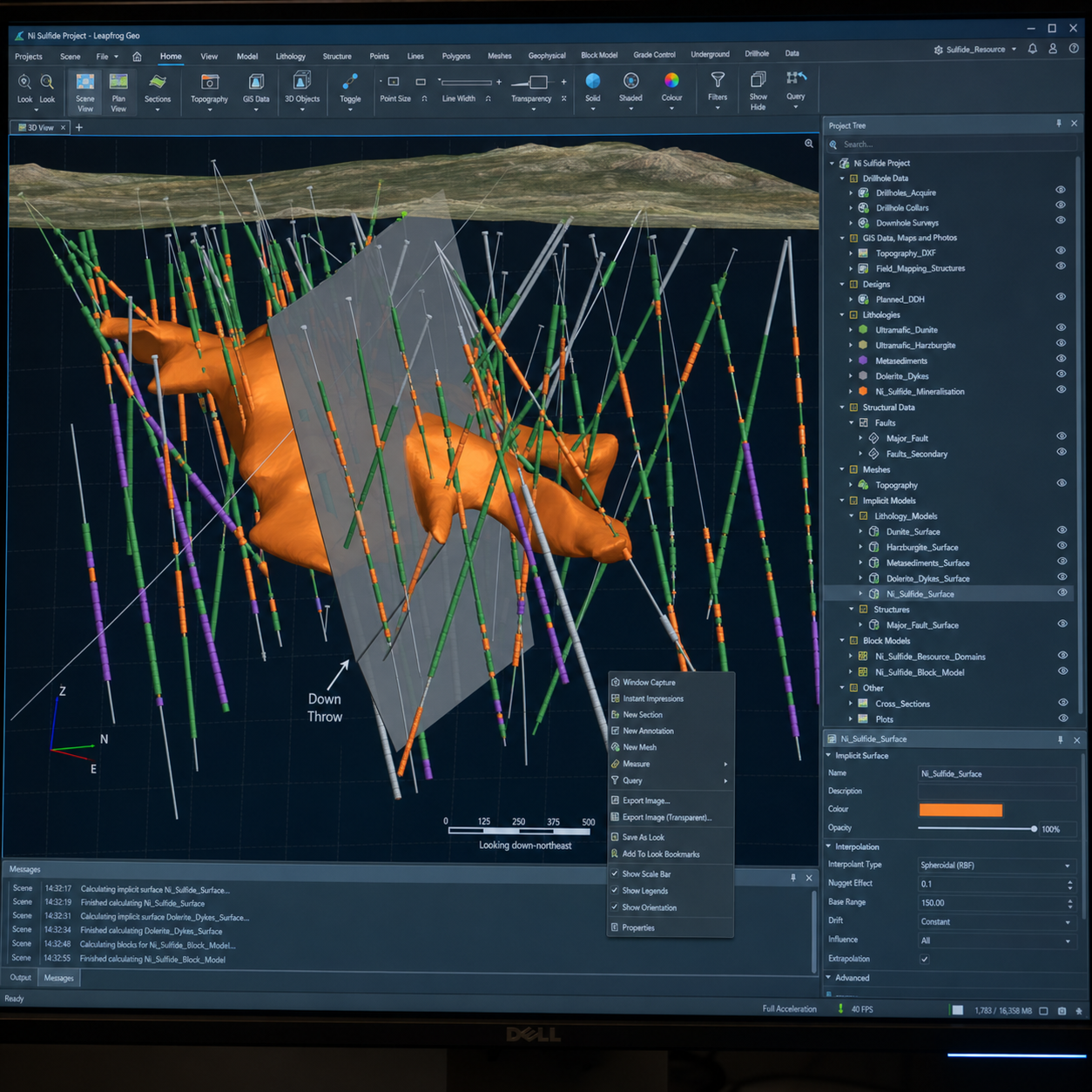
The next step is geological framework modeling. As described by the British Geological Survey, it can be achieved using cross-section, surface interpolation, statistical, or mixed approaches. The cross-section method uses boreholes and maps to help create sections, the interpolation method lets geologists choose boundaries based on information and then creates surfaces between them with computer modeling, while statistical modeling lets software predict what lies between control points, sometimes even resulting in voxel modeling.

The model then undergoes verification through comparison with data. This is essential since 3D modeling is not an exercise for visualization purposes alone but is a way to prove or disprove assumptions regarding geology, including crustal structure, basin geometry, fault zones, hydrological systems, and resource assessment, among others. Besides, many institutions also use 3D models for risk assessment, resource quantification, geohazard evaluation, and public presentations of information.

Various software families are popularly employed in industry. For example, the BGS gives instances where GSI3D software is used for cross-section modeling, Gocad, Isatis, and Move for surface interpolation, and Petrel, SKUA, Isatis, and Gocad software for statistical modeling. Others, depending on the application, are GeoModeller, Surpac, 3DMove, and Voxel Analyst for geological surveys, mining and oil and gas respectively, and geostatistics respectively.

It is common to use data transfer and visualization software too. According to geological survey agencies, for instance, FME is the preferred software for data transfer from one software system to another while some surveys have specialized 3D visualizations to evaluate models along with other geoscientific information. When selecting software in the mining and exploration sector, the main factors to consider include data type, modeling technique, interoperability, and preference for either structural geology, resource estimation, or basin-scale interpretation.

How is a 3D geological model built and what software tools are commonly used in the industry?
0
  • 0 0 Comments
  • 245 Views
  • 245 Reactions
  • 0 Followers
  • 0
    • Report
  • Share
    Share
    • Share on Facebook
    • Share on Twitter
    • Share on LinkedIn
    • Share on WhatsApp

Related Posts

  • Let’s talk about Antamina copper mine.
  • How does ore variability affect mine scheduling and what tools are used to manage it in a multi-element deposit?
  • What role does a Feasibility Study (FS) play compared to a Pre-Feasibility Study (PFS) in advancing a mining project to ...

You must login to add an Comment.


Forgot Password?

Need An Account, Sign Up Here
aalanaalan

Sidebar

  • Recent
  • A rise in gold output is on the horizon for Ivory Coast in 2026, as mining operations across the country ramp up.
    • On: June 12, 2026

    A rise in gold output is on the horizon for ...

  • SigraFi and PeaceGold reach agreement to formalize artisanal gold trading in eastern Democratic Republic of Congo.
    • On: June 12, 2026

    SigraFi and PeaceGold reach agreement to formalize artisanal gold trading ...

  • Ready Mix Concrete Plant Cost for Supporting Crusher Foundations and Heavy Mining Equipment
    • On: June 11, 2026

    Ready Mix Concrete Plant Cost for Supporting Crusher Foundations and ...

  • Increasing Ore Recovery Efficiency with Mobile Crushing & Screening Plant in Mining
    • On: June 11, 2026

    Increasing Ore Recovery Efficiency with Mobile Crushing & Screening Plant ...

  • Operational Synchronization of On-Site Mobile Concrete Mixing Following Aggregate Crushing
    • On: June 11, 2026

    Operational Synchronization of On-Site Mobile Concrete Mixing Following Aggregate Crushing

  • Application Trends of Energy-Saving Crushing Plants in the Peruvian Market
    • On: June 9, 2026

    Application Trends of Energy-Saving Crushing Plants in the Peruvian Market

    • On: June 9, 2026

    Asphalt Batch Mix Plant Structural Compliance for Seismic and High-Wind ...

Go to Home page to view more

Top Members

Olena Skyba

Olena Skyba

  • 150 Posts
  • 2 Comments
Pundit
Marcial

Marcial

  • 91 Posts
  • 0 Comments
Enlightened
Jean Marais (Sanodea Group)

Jean Marais (Sanodea Group)

  • 25 Posts
  • 0 Comments
Beginner
Trending on Mining Doc

Trending Communities

Fixed Plant General Information Geology Mining Case Studies Mining Doc Documentary Mining Engineering Mining Events Mining Finance and Economy Mining Human Resources Mining Industry Research Mining Operations Mining Software Solutions Mining Sustainability Mining Technology Solutions Mobile Plant Equipment

Explore

  • Home
  • Online courses
  • Case study
  • Mining Community
  • Solutions listing
    • Lase Solutions
    • O-PitBlast Solutions
    • Continuous Mining
    • Longwall mining
    • Geosight Scanners
    • LoopX AI
    • Terafil solutions
    • Blasting solutions
    • Geotechnical
    • Submersible Pumps
    • Mine rescue system
    • Ore sorting
    • Whittle Consulting Solutions
  • Add Blog
  • Feed
  • User Profile
  • Posts
    • New Posts
    • Trending Posts
    • Must read Posts
    • Hot Posts
  • Polls
  • Badges

Footer

Mining Doc

Join our community and connect with other people in the Mining industry for knowledge sharing.

Legal Stuff

  • Privacy Policy
  • Terms of Service

Help

  • Support
  • FAQs
  • How to add new content and how to promote a content
  • Compliance and guidelines
  • Subscribe to Mining Doc

Follow

© 2026 Mining Doc. All Rights Reserved