Sign In


Forgot Password?

Don't have account, Sign Up Here

Forgot Password

Lost your password? Please enter your email address. You will receive a link and will create a new password via email.


Have an account? Sign In Now

Sorry, you do not have permission to Add a Post, You must login to Add a Post.


Forgot Password?

Need An Account, Sign Up Here

Sorry, you do not have permission to add Article.


Forgot Password?

Need An Account, Sign Up Here

Please briefly explain why you feel this Post should be reported.

Please briefly explain why you feel this Comment should be reported.

Please briefly explain why you feel this user should be reported.

Mining Doc Logo Mining Doc Logo Mining Doc Logo
Sign InSign Up

Mining Doc

Mining Doc Navigation

  • Home
    • About
    • Contact us
  • Mining articles
  • Online Courses
Search
Sign up

Mobile menu

Close
join for free
  • Home
  • Online courses
  • Case study
  • Mining Community
  • Solutions listing
    • Lase Solutions
    • O-PitBlast Solutions
    • Continuous Mining
    • Longwall mining
    • Geosight Scanners
    • LoopX AI
    • Terafil solutions
    • Blasting solutions
    • Geotechnical
    • Submersible Pumps
    • Mine rescue system
    • Ore sorting
    • Whittle Consulting Solutions
  • Add Blog
  • Feed
  • User Profile
  • Posts
    • New Posts
    • Trending Posts
    • Must read Posts
    • Hot Posts
  • Polls
  • Badges
  • Home
    • About
    • Contact us
  • Mining articles
  • Online Courses

Mining Doc Latest Posts

Mining Doc
  • 0
  • 0
Mining DocExplainer
Added: September 22, 20262026-09-22T07:10:07-04:00 2026-09-22T07:10:07-04:00In: Geology

How to build a reliable 3D structural model when outcrop is limited to less than 10% exposure?

  • 0
  • 0

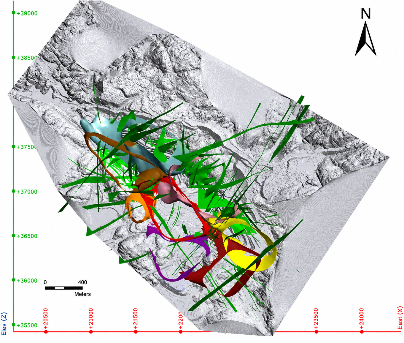
Subsurface characterization in structurally complex mining environments requires the integration of heterogeneous geoscientific datasets. Mineral exploration and mine development routinely face challenges associated with data sparsity, complex deformation histories, and concealed structural hazards. Traditional two-dimensional mapping and isolated profile interpretations frequently fail to capture three-dimensional spatial relationships, leading to increased drilling risk and potential misinterpretations of subsurface ore geometry. Multi-source data fusion resolves these limitations by synthesizing surface remote sensing, borehole logging, geological cross-sections, digital elevation models, and three-dimensional geophysical surveys into a unified digital framework. This integrative approach establishes a Common Earth Model that reflects all available physical observations and geological rules. Consequently, mining professionals obtain a robust foundation for drillhole targeting, resource estimation, structural hazard assessment, and mine design optimization.

The process of geological modeling has advanced from explicit to implicit interpolation approaches. Explicit models depend on cross-sectional digitizing and surface joining. This limits their ability to accommodate heterogeneous data at different spatial scales. Explicit models also demand extensive rework of the models each time new borehole logs and interpreted surfaces are received. Implicit interface modeling seeks to address the challenges posed by explicit models using scalar fields of geochronological stratigraphic sequences. The software employs dual cokriging or radial basis functions for automated creation of stratigraphic surfaces and structural boundaries as isosurfaces. Mathematical representation enables multiple sources of data such as borehole contacts, geological maps, fault traces, and geophysical sections to be accommodated within the model.

Geophysical datasets provide essential subsurface continuity away from sparse borehole control. Three-dimensional geophysical inversions of gravity, magnetic, and magnetotelluric data reconstruct physical property distributions such as density, magnetic susceptibility, and electrical resistivity. Advanced processing workflows, including two-dimensional Kirchhoff prestack time migration, collapse diffraction signals and position dipping reflectors accurately in structurally complex hard-rock terrains. In addition, automated map deconstruction tools and spatial agent-based swarming algorithms enhance structural gradient constraints in sparse-data environments. Spatial agents simulate structural fabric trajectories, fabric dips, and fold plunges by communicating orientation data across local neighborhoods. This automated densification of gradient constraints prevents unrealistic geometric artifacts, enabling geologically plausible surface propagation across complex folded and faulted domain structures.

Quantitative evaluation of fused three-dimensional models delivers actionable insights for mine site safety and exploration efficiency. Structural analyses reveal that major fault zones and fault intersections strictly dictate mineralization trends and fluid migration pathways. In karst-affected mining environments, fused models delineate concealed cave structures, fault patterns, and void geometry, achieving borehole matching degrees above ninety-eight percent. Quantitative spatial analysis enables susceptibility evaluations for ground collapse, identifying high-risk zones where excavation or groundwater extraction must be carefully managed. Furthermore, multi-parameter model integration optimizes drillhole targeting by quantifying spatial uncertainty. Mine operators can strategically place subsequent drillholes in areas of maximum uncertainty, reducing total required meterage while maximizing information gain. Improved subsurface rock characterization also optimizes blasting, crushing, and mineral recovery processes.

Multi-source data fusion represents a transformative capability for modern mining geology and engineering. The convergence of implicit modeling algorithms, advanced seismic prestack migration, three-dimensional geophysical inversions, and automated structural agents bridges the gap between surface observations and deep subsurface reality. Fused Common Earth Models eliminate spatial ambiguities, validate structural interpretations, and quantify operational risks prior to capital expenditure. As mining operations venture into deeper deposits and more complex tectonic settings, dynamic data fusion workflows will remain essential for sustainable resource extraction and risk management.
How to build a reliable 3D structural model when outcrop is limited to less than 10% exposure?
0
  • 0 0 Comments
  • 22 Views
  • 21 Reactions
  • 0 Followers
  • 0
    • Report
  • Share
    Share
    • Share on Facebook
    • Share on Twitter
    • Share on LinkedIn
    • Share on WhatsApp

Related Posts

  • What are the key indicators separating orogenic gold systems from intrusion-related gold systems in the field?
  • What's the correct method for logging RQD and core recovery to ensure defensible geotechnical domain models?
  • What's the practical workflow for using portable XRF data in the field without compromising assay-grade decisions?

You must login to add an Comment.


Forgot Password?

Need An Account, Sign Up Here
aalan

Sidebar

Sponsored Ads

aalan
  • Recent
  • Legal Validity of OTR Tire Supply Contracts: How Technical Appendices Protect the Interests of Mining Enterprises
    • On: September 21, 2026

    Legal Validity of OTR Tire Supply Contracts: How Technical Appendices ...

  • Mobile Crusher for Sale Philippines for Producing Road Base and Construction Aggregates
    • On: September 18, 2026

    Mobile Crusher for Sale Philippines for Producing Road Base and ...

  • Customs Clearance and Logistics Practices for Imported Crusher to Chile
    • On: September 18, 2026

    Customs Clearance and Logistics Practices for Imported Crusher to Chile

  • Mining ERP: Bridging the Gap Between Planned and Actual Costs
    • On: September 14, 2026

    Mining ERP: Bridging the Gap Between Planned and Actual Costs

  • Ore Crushing Plant for Mountain Mines: Managing Access, Transport, and Production
    • On: September 12, 2026

    Ore Crushing Plant for Mountain Mines: Managing Access, Transport, and ...

  • How Does the Crushing Chamber Design of Aggregate Crushing Equipment Affect Output and Finished Product Quality?
    • On: September 12, 2026

    How Does the Crushing Chamber Design of Aggregate Crushing Equipment ...

  • How Can Mine Construction Teams Reduce Rework During Fast-Track Projects?
    • On: September 8, 2026

    How Can Mine Construction Teams Reduce Rework During Fast-Track Projects?

Go to Home page to view more

Top Members

Olena Skyba

Olena Skyba

  • 150 Posts
  • 2 Comments
Pundit
Marcial

Marcial

  • 91 Posts
  • 0 Comments
Enlightened
Jean Marais (Sanodea Group)

Jean Marais (Sanodea Group)

  • 26 Posts
  • 0 Comments
Beginner
Trending on Mining Doc

Trending Communities

Fixed Plant General Information Geology Mining Case Studies Mining Doc Documentary Mining Engineering Mining Events Mining Finance and Economy Mining Human Resources Mining Industry Research Mining Operations Mining Software Solutions Mining Sustainability Mining Technology Solutions Mobile Plant Equipment

Explore

  • Home
  • Online courses
  • Case study
  • Mining Community
  • Solutions listing
    • Lase Solutions
    • O-PitBlast Solutions
    • Continuous Mining
    • Longwall mining
    • Geosight Scanners
    • LoopX AI
    • Terafil solutions
    • Blasting solutions
    • Geotechnical
    • Submersible Pumps
    • Mine rescue system
    • Ore sorting
    • Whittle Consulting Solutions
  • Add Blog
  • Feed
  • User Profile
  • Posts
    • New Posts
    • Trending Posts
    • Must read Posts
    • Hot Posts
  • Polls
  • Badges

Footer

Mining Doc

Join our community and connect with other people in the Mining industry for knowledge sharing.

Legal Stuff

  • Privacy Policy
  • Terms of Service

Help

  • Support
  • FAQs
  • How to add new content and how to promote a content
  • Compliance and guidelines
  • Subscribe to Mining Doc

Follow

© 2026 Mining Doc. All Rights Reserved